Robotics and Wearable Computing for Geological Exploration on Mars
Patrick C. McGuire
Robotics Group & Transdisciplinary Laboratory
Centro de Astrobiología, INTA/CSIC
Instituto Nacional Tecnica Aeroespacial
Torrejon de Ardoz, Madrid, Spain
Donnerstag, 30.09.2004, 14 Uhr c.t., H9
First, I will give an introduction to the current state-of-the-art in the
geological exploration of the Martian surface by NASA's Mars Exploration
Rovers, Spirit & Opportunity. Second, I will present the first field
results from a wearable computing system that we are using in Spain to
develop and test computer vision algorithms for geological exploration
here on the Earth. Such computer vision algorithms (programmed using
Bielefeld's NEO graphical programming language) could be employed in
robots for future geological exploration of the Martian surface.
In March and June 2004, we tested the `Cyborg Astrobiologist' at a
white-and-tan-colored gypsum-bearing gological outcrop near Rivas
Vaciamadrid. The Cyborg Astrobiologist is a wearable computer and robotic
video camcorder system that we are using to test and train a
computer-vision system towards having some of the autonomous
decision-making capabilities of a field-geologist. The Cyborg
Astrobiologist platform has thus far been used for testing and development
of these algorithms and systems: robotic acquisition of quasi-mosaics of
images, real-time image segmentation, and real-time determination of
interesting points in the image mosaics. In addition to the
proof-of-concept aspect of these field tests, the main result of these
field tests is the enumeration of those issues that we can improve in the
future, including: dealing with structural shadow and microtexture, and
also, controlling the camera's zoom lens in an intelligent manner.
Despite these inadequacies, the Cyborg Astrobiologist has demonstrated its
ability of finding genuinely interesting points in real-time in the
geological scenery, and then gathering more information about these
interest points in an automated manner. Particularly, the system was able
to autonomously identify as unusual, and then proceed to study further,
two mid-sized dark regions on the outcrop. These two dark regions were
caused by water leaking out of the outcrop.
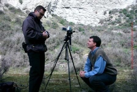
Figure 1: Human Astrobiologist & Geologist Ormö is wearing the computer part of the
Cyborg Astrobiologist system, as Human Astrobiologist & Roboticist McGuire looks on. During this pictures, the robotic
part of the Cyborg Astrobiologist was slaving away, acquiring & processing the images of a 9
x 4 vertically oriented mosaic. These pictures were taken during the March 3rd expedition to
Rivas Vaciamadrid. Note the absence of the black spots near the bottom of the cliff face; these
black spots appeared sometime after this 1st mission and before the 2nd mission. Photo Copyright:
Díaz Martinez, Ormö & McGuire
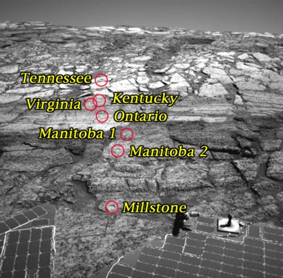
Figure 2: This image taken by the navigation camera on the Mars Exploration Rover Opportunity
shows the first seven holes the rover drilled into the slopes of "Endurance Crater." Starting from
the uppermost pictured (closest to the crater rim) to the lowest, the holes were drilled on sols
138 (June 13, 2004), 143 (June 18), 145 (June 20), 148 (June 23), 151 (June 26), 153 (June 28) and
161 (July 7), respectively. Each hole is 4.5 centimeters (1.8 inches) in diameter.
Each of the holes has a name for the rock it is on, and for the specific target on the rock. On
the rock "Tennessee," the target is "Vols;" on the rock Kentucky, the target is "Cobblehill;" on
the rock "Virginia," the target is Virginia; on the rock "Ontario," the target is "London;" on the
rock "Manitoba," the targets are "Grindstone" and "Kettlestone;" on the rock "Millstone," the
target is "Drammensfjorden." (Image courtesy of NASA:
http://marsrovers.nasa.gov)
